

START: Flamborough North Landing, East Yorkshire
FINISH: Bridlington, East Yorkshire
DISTANCE: 8.5 miles (Total – 340.3 miles)
APPROXIMATE TIME: 3.5 hours
OS MAPS: OS Explorer 301
ACCOMMODATION: The Almar Guest House, Scarborough
My legs were tired for this third day’s walk along the Yorkshire coast. Whilst this section of the coastline from Scarborough to Bridlington is stunningly beautiful, it can be very hard on the legs with all the ups and downs of the coastal path. Still, today’s walk was only a short walk and it promised to be another excellent walk. Boosted by an excellent Full English breakfast courtesy of The Almar Guest House in Scarborough, I re-traced the journey back to Flamborough North Landing where I head left off the previous day (see Coastwalk #28) . First I got the train from Scarborough to Bridlington and then hopped on the 510 bus which took me out of the east of the town, through Flamborough village and then finally to the end of the line at North Landing.
FLAMBOROUGH NORTH LANDING
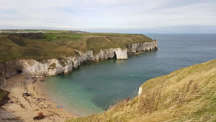
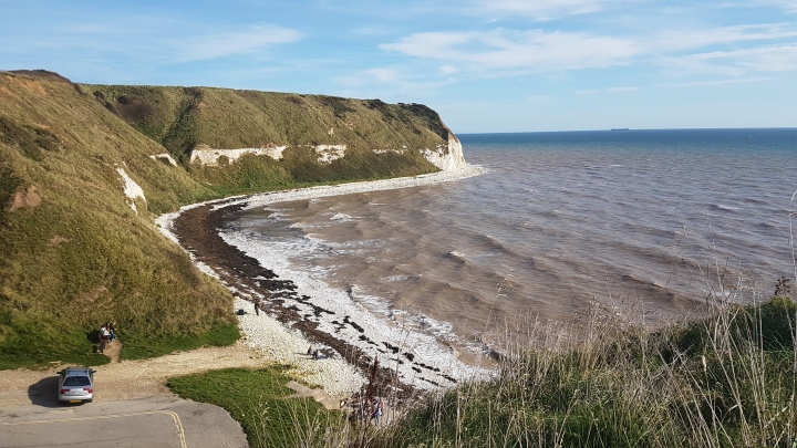
There were plenty of people gadding about which wasn’t surprising as it was a lovely sunny Saturday, although it was a bit blustery. From the bus stop I walked past North Landing cafe and rejoined the Headland Way as it followed the eastern edge of North Landing Bay. Once again the views were glorious, and I could clearly make out Bempton Cliffs further up the coast where I had walked the previous day. The coastal path hugged the clifftops as it meandered its way along them. I saw one bloke riding his bike along the path which must have been a little dangerous considering the gusty winds and the lack of barriers between the path and the sea.
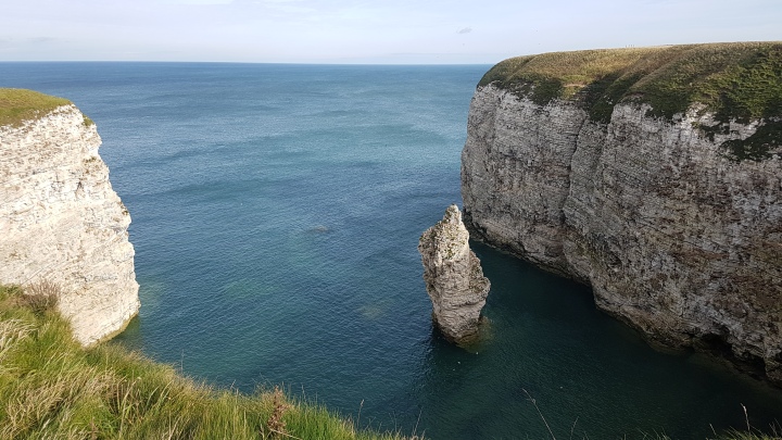
I passed by numerous little coves lined with fantastic chalk cliffs (above). Dozens of seabirds could be heard squawking as they nestled on the cliff face. After about a mile the path came to a golf course which I had to walk round the edge of. I’m not a huge fan of walking around golf courses as you always have to be on the lookout for wayward golf balls. Fortunately this time I didn’t have to worry as a lot of the golfers seemed to be at the other end of the golf course to where I was walking.
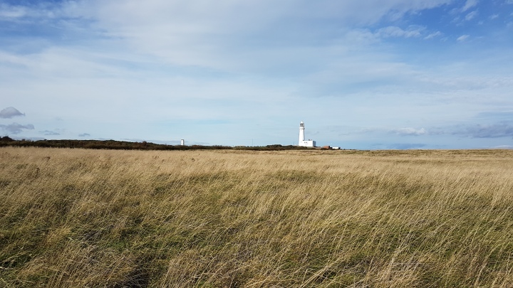
I continued to follow the path and ahead I could see the lighthouse at Flamborough Head. Before I got there though I had to negotiate a couple of set of steps as the path once again hugged the coastline. Finally I came out onto a grassy patch next to a road which I followed until I reached the lighthouse.
FLAMBOROUGH HEAD
 Flamborough Head has always been a dangerous obstacle to shipping due to the many chalk reefs and outcrops which can be obscured by the crashing waves, coupled with the locally strong tidal currents. Records of ships being lost to the sea off Flamborough Head go back several hundred years with the earliest recorded, La Katerine, being stranded on the rocks off the headland during a severe storm in 1348.
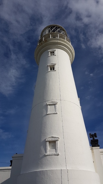
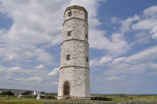
Over a thirty-six year period at the end of the 18th century, one hundred and seventy five ships were lost off Flamborough Head, at the rate of one every twelve weeks. Clearly something needed to be done and in 1806 Trinity House (the organisation responsible for the building and upkeep of lighthouses around the British coast) constructed a lighthouse (right) at the cost of £8000. It was hoped that this new lighthouse would seriously reduce the number of ships lost off Flamborough Head. This lighthouse wasn’t the first to be built at Flamborough Head. An octagonal chalk tower (below) was built a little further inland in 1674 by Sir John Clayton who was given permission by King Charles III to build three light towers around Britain. The light tower was the only one built as Sir John Clayton later went bankrupt, however it has never been lit to this day.
From the lighthouse I headed down the path towards the fog signal station which gives two blasts every ninety signals during foggy weather, which is a call unique to Flamborough Head. Just past the signal station I stopped for a little to look out to sea where in 1779 Flamborough Head found itself unwittingly caught up in the American War of Independence.
THE BATTLE OF FLAMBOROUGH HEAD
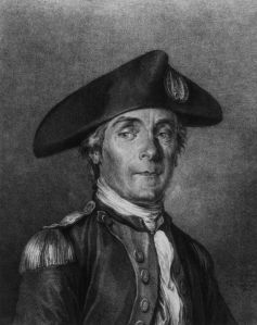
On the 23rd September 1779 a large British convoy of ships headed by the HMS Serapis were sailing along the Yorkshire coast when they were intercepted off Flamborough Head by a combined squadron of French and American ships headed by John Paul Jones, on the Bonhomme Richard. John Paul Jones along with a flotilla of three ships had been terrifying the east coast of Britain for the previous few weeks. He had led the people of Leith and Edinburgh in Scotland into a frenzy when he showed up outside the undefended port of Leith during August 1779. John Paul had a ferocious reputation gained from raiding the Cumbrian coastal town of Whitehaven in 1778 and attempting to kidnap the Earl of Selkirk in the same month so unsurprisingly the inhabitants of Leith and Edinburgh were a bit skittish.
Fortunately gale force winds prevented John Paul from landing at Leith so he headed southwards, firing at the small Northumberland port of Alnmouth (see Coast Stories #1), capturing a brig off the Northumberland coast, and allegedly raiding the coastal village of Skinningrove in North Yorkshire, before coming across the British convoy off Flamborough Head.
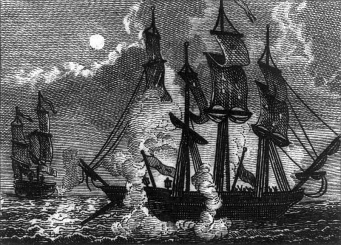
The battle was fierce with the HMS Countess of Scarborough soon being captured. The main action was between the HMS Serapis and the Bonhomme Richard. The engagement lasted for about three hours until around 10.20pm when John Paul Jones succeeded in forcing the British ship to surrender. Ultimately the Bonhomme Richard would sink the following morning due to damage sustained in the battle, however John Paul Jones returned to France and later the United States somewhat of a folk hero in both countries for overpowering a superior enemy.
I continued to follow the coastal path and got a complete change of scenery as the path rounded the headland. On a clear day you can see the dark outline of Flamborough Head right on the horizon and it is almost in constant view as you head down the coast all the way from Robin Hood’s Bay. However, now that I’d got Flamborough Head out the way I could begin to see what was beyond the headland – the Holderness coast which stretches all the way from Bridlington down to Spurn Point at the mouth of the Humber. This section of the coastline is one of the most eroded in the whole of Europe.
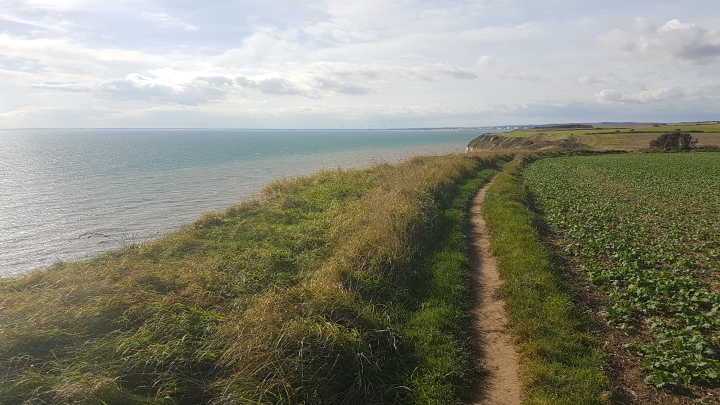
The view across to the Holderness coast was beautiful with the sun glistening off the sea and also off the windows of the buildings in Bridlington, just a little further down the coast. The crowds had thinned out at this point and it seemed like I had the whole coastal path to myself. I decided to stop for lunch a little while and sat down on a grassy patch which overlooked the sea. It was very peaceful and quiet as I sat munching on my sandwiches and the break did my tired legs a world of good.
SOUTH LANDING
My lunch break over, I was back on my feet once again and continued to follow the coastal path as it meandered along the clifftops. Soon South Landing was reached and the path descended down some steep steps into this beautiful little cove (below). There is a lifeboat station at South Landing which has been operation since 1993. There had been a station in operation on this site from 1871 to 1938 which ran in conjunction with another lifeboat station at North Landing, the idea being that if the weather or sea prevented the launch of a lifeboat from one station then hopefully a lifeboat could be launched from the other station, so providing continuous coverage around Flamborough Head. The South Landing lifeboat station was closed in 1938, however was re-opened in 1993 with the closure of the North Landing station. Since 1871 the Headland’s lifeboat crews have saved over 540 lives.
I climbed up the steps at the other end of the cove and was soon back on the clifftops again. About a mile later I came across the southern end of Dane’s Dyke, the Bronze age defensive fortification which stretches from one side of the Headland to the other. This southern end of the Dyke was sheltered under a green canopy of trees which provided a welcome shade from the hot sun. I climbed down another set of steps down into a wooded valley before climbing immediately back out again where the footpath continued once more along the clifftops.
Ahead the path edged around a golf course before coming alongside a cricket pitch which was lined with wooden benches. Behind the cricket pitch I could make out the 18th century built Sewerby Hall which is open to the public. A little further on I stopped at one of a series of benches which overlooked the sea. There were a good number of people about enjoying the sunshine and in the distance I could see Bridlington looking very busy.
BRIDLINGTON
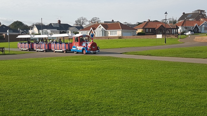
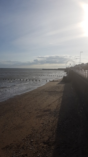
My short break over I was ready to make the final push into Bridlington. The coastal footpath ran parallel to a narrow road along which I saw one of the land trains rattling along between Bridlington and Sewerby Hall. It wasn’t long before the land train passed me going back to Sewerby Hall as I was going quite slow at this point – the three days walking making my legs and feet feel extra tired. However, I was feeling extra buoyed by the warm weather and the fact that I was approaching the end of the walk in Bridlington. I reached the start (or end depending on which you’re walking) of Bridlington’s promenade. Even though it was the middle of October it did feel like it was in fact the middle of the summer with the promenade absolutely teeming with people.
Bridlington has been popular with holidaymakers since the early 18th century with wealthy people coming from all over Yorkshire and beyond to the developing seaside resort with their families to sample the sea air. With the arrival of the railway in the town in 1846 thousands of working class people from the great industrial cities of the North descended on the resort. New facilities were opened for the new visitors including a spa hall, a promenade and theatres.
By the 1920’s Bridlington was in the top ten of British resorts in terms of visitor numbers and this continued well into the 1960’s. Like most British seaside resorts Bridlington did go into decline in the 1970’s as a result of the rising popularity of package holidays abroad, however Bridlington has been able to re-invent itself over the following decades and remains one of Britain’s popular seaside resorts.
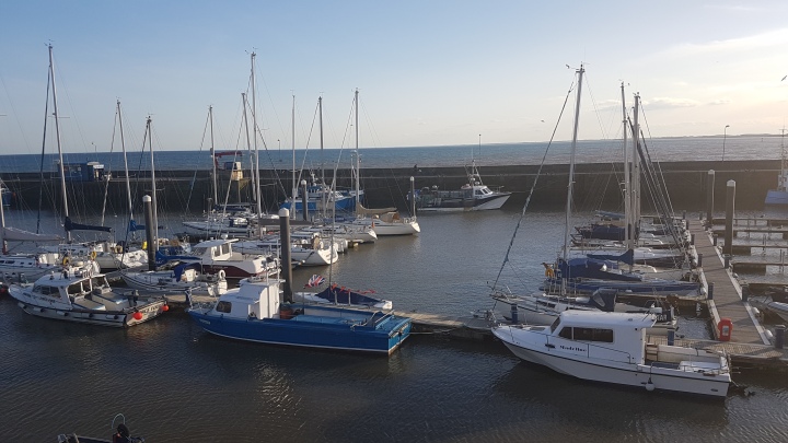
I could see this popularity for myself as I walked along the promenade, soon passing by amusement arcades and a small fairground which were chocked full of people. I stopped to get myself an ice cream (chocolate chip in case you were wondering) and took a seat overlooking the harbour which was filled with boats.
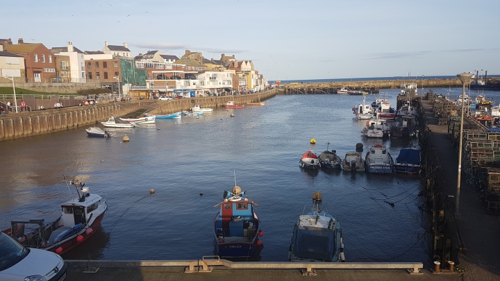
Bridlington has been a fishing port since the Middle Ages. There are records from 1667 of a coble working locally landing a 22 1/2 ft fish from the bay. Traditionally cod and haddock were the main sources of income, however as the decades have passed, particularly in the latter half of the 20th century, local fishermen have turned their attentions to the abundance of crab and shellfish in Bridlington Bay. As such, Bridlington is now known as one of Europe’s premier shellfish ports, so ensuring the future of the port.
The harbour itself owes its continued development over the centuries due to its importance as a ‘bay of refuge’, particularly from the late sixteenth century onwards with the increase of collier ships laden with coals making the perilous journey from Newcastle to London. The North Sea has always been a treacherous body of water and when conditions turned sour Bridlington Bay offered one of the few places of refuge on this part of the coast. Sometimes these ships would have to anchor up for weeks on end and it wasn’t uncommon to see more than three hundred vessels in the bay waiting for storms to pass. Naturally the crews of these ships had to be fed and watered and a roaring trade took place in Bridlington to supply the ships with beef, bread, water and salt.
Parliament recognized Bridlington’s importance as a port of safety in 1697 when they granted the port the status of a harbour of refuge. This Act also created the Bridlington Harbour Commissioners who collected tolls from colliers leaving the Tyne and Wear ports. This money was used to improve the harbour and develop it to its present size to accommodate the larger ships that sailed the seas at the time. Bridlington’s role as a harbour of refuge continued well into the nineteenth century and it still continues this role, albeit a much smaller one in the 21st century.
Sadly, my walk had come to an end. Before I headed off to the railway station to catch the train back to Scarborough I took one look down the Holderness coast knowing that I probably wouldn’t be back this way for a couple of years. As mentioned earlier the Holderness coast is eroding at a tremendous rate meaning that the coastal path that was in place has completely disappeared in a number of places, which would mean that I would have to walk along the beach for several miles (with very few safe exit points from the beach) or walk along busy roads much further inland. The England Coast Path will eventually create a coastal footpath from Bridlington to Spurn Point, however it is not due to be completed until 2020. So in the meantime my attention turns back to Scotland and to North Queensferry where I left off at in September 2017 (see Coastwalk #26). I will return to the Fife coast in the spring of 2018 and I wonder how far I will get before my attention turns back to the Yorkshire coast again in 2020 – Aberdeen is a good possibility, so is Inverness. How about John O’Groats, or maybe the whole coast of Scotland maybe? Who knows how far I will get? The only way to find out is to read this blog! Happy reading!
REFERENCES
Flamborough Head
http://www.flamboroughheadsac.org.uk/storyboards/lighthouse/
Click to access North%20Landing%20to%20Fog%20Signal2.pdf
The Battle of Flamborough Head
Click to access Battle%20of%20Flamborough%20Head.pdf
http://georgianedinburgh.blogspot.co.uk/2012/02/john-paul-jones-and-building-of-leith.html
South Landing
http://www.flamboroughheadsac.org.uk/storyboards/history/
Bridlington
http://www.bridlingtonheritage.com/tourism

We love this walk – glad you got to see it on a ☀️ Day 🐾👣
LikeLiked by 1 person